Day 36. Mizpah Hut to Madison Springs Hut. 11.8 miles.
Ate breakfast, said goodbye to Shadow, Neon, and Mosey and left before the hut began their morning skit. Long day ahead making it all the way across the Presidentials.
Mark Trail had the same plan, but he was also planning on tagging optional summits along the AT. He therefore went ahead since he hikes faster and had more work to do, so to speak.
Made the steep climb from Mizpah Hut to Pierce. Hooray for views! Lovely clear day today. I put on sunblock since today had massive sunburn potential.
Made my way across the Presidentials with a thousand memories in every mile. Here is where Alex and I broke trail in a white-out between Pierce and Eisenhower. Here is where I waited for Sage as she tagged a winter Grid peak I already had (Sphinx Col, Jefferson). Here is where the girls had their first hut stay (Lakes of the Clouds way back in 2008 when they were five and three). Here is where we enjoyed so many gorgeous winter days with rime ice on the signs and views clear to the ocean (Washington).
I stuck to the AT and did not do optional peaks since I’ve done them all before.
The Lakes of the Clouds hut croo were kayaking at the lakes. Fun!
Got to Mt Washington around 11am. It was the typical summer circus up there. I stuck to the trail and skipped the line to the summit sign. Quickly filled my water bottle in the Visitor Center and left the area. Way too many people for me, all moving slowly and stopping in the middle of the path for no apparent reason, etc.
Went down Washington, waved at the people riding up on the Cog Railway, went up and past Clay down into the col, then did the arduous boulder-hop up Jefferson. The AT/summit bypass starts almost all the way up the summit, and the footing on the bypass is so rocky that I am not sure one saves much effort using it as opposed to going over the actual summit. Also, I had forgotten how gnarly parts of the path were between Jefferson and Adams.
In spite of, or because of, its difficulty and wildness, I really love the northern Presis. Beautiful, other-worldly, you feel like you’re on the moon.
Trudged up my last ascent of the day, Adams, and said hello to Thunderstorm Junction. I love that spot! An intersection of many trails, right underneath Adams’ peak, huge cairn, space to sit and take a break.
I was physically and psychologically ready to be done for the day, and the hut was now only a mile away, so I didn’t linger and continued along until I reached that special place where you can see Madison’s peak looming above the hut. Love that view. Took a photo, then descended to Madison Springs.
Claimed my spot, arranged my things, cleaned myself up a bit, bought some snacks for tomorrow, drank free lemonade and bought some coffee cake, then greeted Mark Trail when he arrived. He had a great hiking day, and I am happy for him. Now I rest in my bunk waiting for dinner. I have a top bunk with lots of hooks and some shelf space. Everything of mine fits up here. There is room for one other person across the ladder from me, kind of hope no one takes that tonight so I can have this entire corner to myself.
Happy I am not as sunburned as I thought I would be. I kept reapplying sunblock all day, guess it worked.
This is my favorite hut. You have to work to get here, there is no easy way. Lots of hiking involved from every direction, and it sits high up between Madison’s summit cone and the peak of JQ Adams.
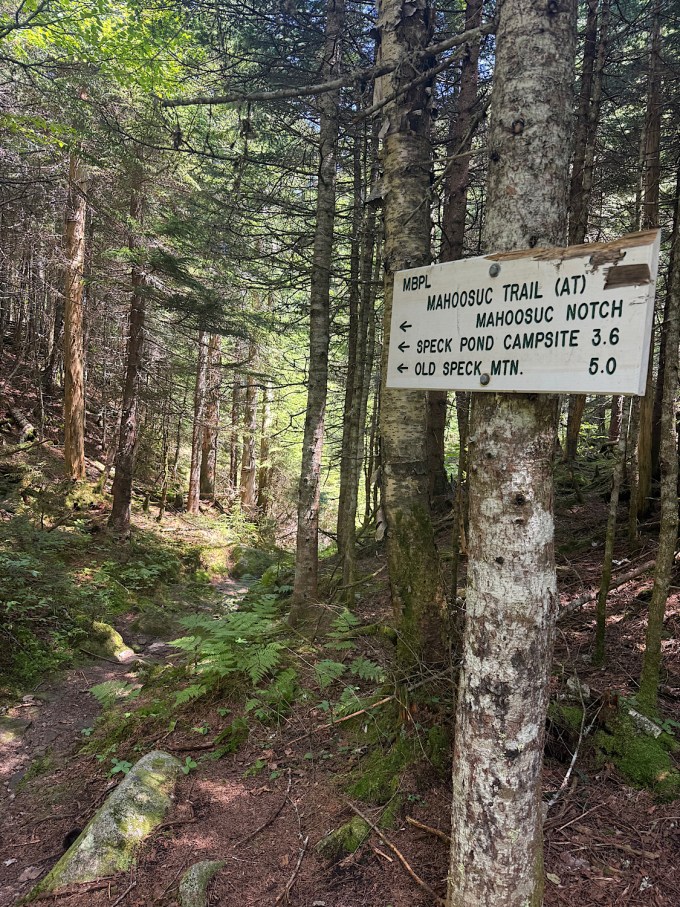
Tomorrow’s forecast looks sketchy with lots of rain. Hopefully I’ll be below treeline before the deluge begins. I am staying at Carter Notch Hut tomorrow night. After that, it is just getting over the Carters/Moriah and then I am finished with the Whites. Technically the Whites extend through the Mahoosucs to Grafton Notch in Maine, but thruhikers lump the Mahoosucs in with the “southern Maine” category.
Shoot, a guy just arrived who will take that other top bunk. Oh well. He seems nice, anyway.


Day 37. Madison Springs Hut to Carter Notch Hut via the AT reroute. 10.7 miles
A bridge is out along the AT, so there is a reroute that counts this year for thruhiking status. It puts you on Route 16 and then along 19 Mile Brook Trail to Carter Notch, skipping the Wildcats. One can do the Wildcats anyway and still avoid the broken bridge if one really wants to, but since I have already done the Wildcats numerous times, I opted for the detour.
Forecast called for rain and lightning in the late morning/early afternoon, so I got out of the hut as soon as I could after breakfast. Mark Trail went ahead of me, and I don’t know if I will see him again. Such is the nature of thruhiker connections.
Got up Madison fairly quickly. Windy with views and an overcast sky, perfect for fast hiking. Made my way down the very exposed Osgood Trail and reached treeline. Thanked the mountain for keeping me safe and thanked the Universe for not lightning on me while I was so exposed.
Once below treeline, I could feel the heat and humidity creep in. Took the detour, which had much better footing than the normal route, got to the road, walked past where my daughters and I would emerge during winter Carter hikes after taking a bushwhack/shortcut on the descent, walked to 19MBT, and did the four miles to Carter Notch Hut. Thought I could make it all the way without getting rained on, but when I got within a mile of the shelter the skies opened. Arrived drenched at the hut. The croo didn’t mind. Ate a baked good, drank free lemonade, ate a free pancake, claimed my bunk room – which I have all to myself tonight! – washed up (though I still manage to smell like feet), wringed out my clothes (brown water emerged, ew), spoke to other guests, and am now relaxing.
I have stayed at this hut only once before, with my girls when they were little. They swam in one of the lakes/ponds and had a good time. Fond memories.
Tomorrow will be a big day. I have to get over all the Carters and Moriah – tough terrain. That is going to be difficult!! I didn’t remember how many miles that was until I already made reservations in Gorham. Over 15 miles…yikes. Yesterday was 12 and it wiped me out. It will be the last of the NH Whites though. It was good to be back.


Day 38, Carter Notch Hut to Route 2, 15.2 miles
It poured rain all night, so glad I was in the hut.
Met Mike, a guy attempting a 24-hours hut-to-hut traverse. He left right after breakfast. Nice guy, I hope he makes it.
Met two other guys who are here for day hikes they have hiked a ton all over the world. Had fun talking trails with them.
Temps were cool and wind speeds high as I climbed up Carter Dome. No bugs, chilly, perfect. The climb was not as difficult as I’d remembered. I am getting stronger.
Mt. Height was in the clouds, and the winds were strong enough to push me around.
Lots of fond memories as I revisited South and Middle Carter. The sky cleared, and I began to have views. Lovely!
The temps remained cool enough for me to wear my long-sleeve merino wool shirt much of the day. Love that!
Had not remembered all the steep down climbs coming off North Carter. That slowed me down a ton.
The climb up Moriah on Stony Brook Trail was prettier than I’d remembered.
Did not visit the actual summit of Moriah since I have been there/done that and it is not actually on the AT.
The climb down Moriah on Rattle River Trail is a long series of rock steps for the first two miles. I carried a cake up this trail when my younger daughter finished her 52WAV on neighboring Shelburne Moriah!
My knees and legs were happy when the trail flattened out for the final two miles.
Nancy from Four Corners Motel met me at the trailhead. It had been a long day, and I got there later than I’d expected (about 5).
Got to the motel, bought dinner, showered (first time in a week!), did laundry, took care of a few personal matters, and finally got to bed at midnight. Am thinking of making this a double zero before I go up the Mahoosucs. My legs are beat from the Whites, and I know southern Maine has equally tough terrain.


Days 39 and 40. Double zero in Gorham, NH.
Had planned a zero in Gorham after finishing the unforgiving Whites so I could rest up a bit before tackling the equally difficult Mahoosuc Range. Heavy rain and thunderstorms forecasted for the very next day prompted me to take off that day too. I now have a perfect forecast of temps in the 60s and strong winds for the three days it should take me to get through the Mahoosucs to Grafton Notch.
Got to finally meet long-time internet-friend and hiker extraordinaire Rachel Flaksman while I was in Gorham! In addition to having hiked all things NH and New England, admin-ing the FB WMG Redlining page, and co-moderating my T25 FB page, Rachel travels all over and hikes in other gorgeous places too. She is extremely experienced and incredibly knowledgeable. I enjoyed hearing about her recent Bay of Fundy hike, and I look forward to following her upcoming Granite Peak adventures. She and I share a love of the National Park system, so we discussed a bit of Park-related stuff as well. I enjoyed talking with her and wish I had more opportunities to do so. Rachel also took me to Walmart for resupply, which was super helpful.

Day 41, Rattle River Trailhead (NH) to Carlos Col shelter area (Maine). 17 miles
Got dropped back off at the trailhead at 6:15am. The hike up Mt Hayes wasn’t as difficult as I thought it might be even given my heavy-with-resupply backpack.
Saw some lovely ponds and did a bunch of ups and downs that didn’t feel too steep.
The fun started with Mt Success. Steep boulders straight up until a few tenths of a mile near the top where everything turned into ledges. Lots of blueberries today! Tasted good.
Windy up top Success, but great views. The way down was tedious, and then there were ups and downs that turned into rock scrambles and sketchy downclimbs followed by little steep bits until I reached the NH/Maine border.
Crossed into Maine!
I’d gone farther than I’d intended and it was time to find a place to camp. Carlos Col Shelter was coming up, so I made the decision to head there. Got to experience a difficult and dangerous downclimb over large boulders right before the shelter spur, right when I was extremely tired and just wanting to be at the camping area already. Also had to hike DOWN 0.3 mile off trail to get to the shelter/campsite. This means I have to hike back up those 0.3 tomorrow. Arg.
Today wasn’t exactly easy, and tomorrow will be much more difficult with Mahoosuc Notch and the Mahoosuc Trail in general.
Was hoping it would be a quiet night with few people at this shelter area, but alas, three loud guys just showed up. Can’t tell if they are thruhikers or locals out backpacking. It is kind of late for their noise, hope they pipe down soon.


Day 42, Carlos Col Shelter to Speck Pond Shelter. 9.9 miles
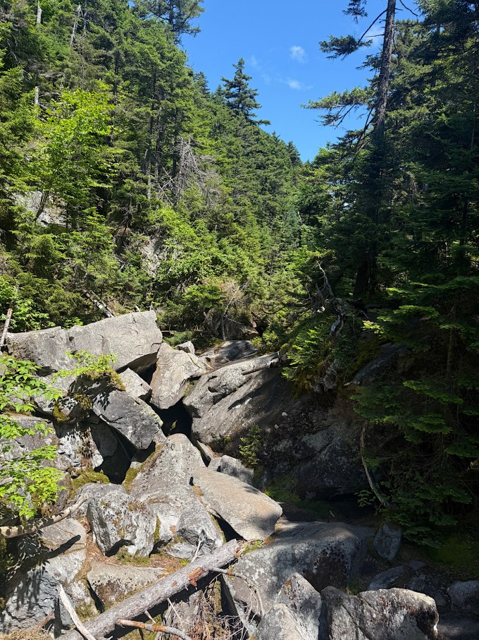
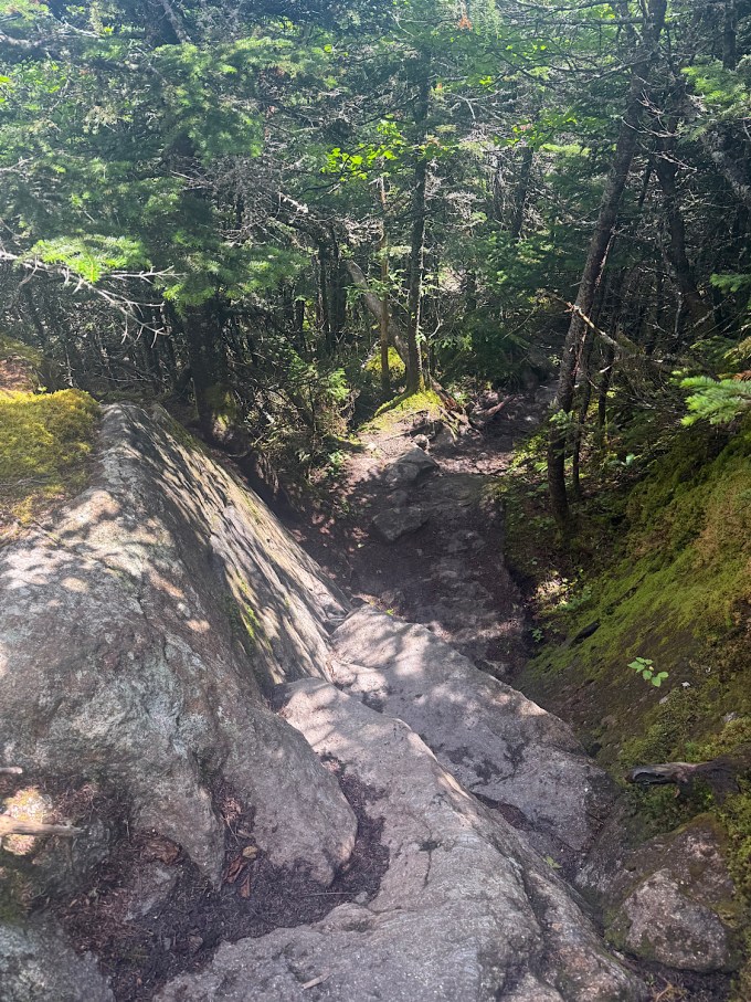
Everything hurts! The terrain today is the toughest part of the AT! Gorgeous above-treeline views interspersed with boulder climbing, ladders, eroded dirt, tree roots, extreme steepness, and of course the infamous Mahoosuc Notch and Mahoosuc Arm. Spent most of my day trying not to get injured. Took me 12 hours to go those 9.9 miles.
For those who don’t know, Mahoosuc Notch is 0.9 miles of massive boulders one must climb up and over/under/through. Dangerous and time-consuming. Had to take off my pack three times to shove it through tight squeezes. My pack now has a small hole (now patched with Tenacious Tape). I did so much butt-sliding that the left half of my merino wool shorts are ripped out. Any gusts of wind over the next couple of days will expose the left half of my ass until I can get to a gear store for new shorts/boxers.
Mahoosuc Arm is a straight up mile climb over boulders and eroded roots.
Am now at Speck Pond Shelter. Martian and Finn are here! Happy to see them again. I spoke with Martian for a while, then ate and retreated to my tent. It is difficult for me to lay flat on my back. My legs hurt. My ass is scraped up. My elbow is bloody. Mahoosuc Notch and Arm tried to kill me.
Met NOBOs Dust, Heartbeat (he helped me down a tricky descent just before the Notch), Sticks & Stones, Hound Dog, and Bullseye today in passing.
I am too exhausted to write anything else.