Day 113. 20 miles
James River Bridge Footbridge/SOBO mile 1411.0 to Cornelius Creek Shelter/SOBO mile 1431.0
What a perfect hiking day! Cool temps, low humidity (for once!!), and clear skies.
Began my day with a breakfast of omelettes and pancakes at Stanimal’s, then got on trail around 7:45. Had a ton of elevation gain in my forecast, but my mood was chipper because of the lack of humidity, cool temps, and good food in my belly.
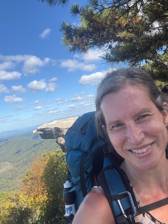
The ascent to Highcock Knob (yes, you read that correctly) had tons of ridge views. It was just lovely. Then there was a slight descent and another, longer climb up to 4203-foot Apple Orchard Mountain. Those two ascents were the first 16 miles of my day, so most of my time today was spent going up, just under 5000 feet of total elevation gain. Apple Orchard Mountain has a weather radar station on the top that looks like a giant golf ball. Just before the summit, there is an interesting rock formation called The Guillotine.
The remaining four miles was mostly descending with a couple of minor ups. I’m now camped at Cornelius Creek Shelter. I can hear cars on the Blue Ridge Parkway below. There is no trail directly to the Parkway from here though, so this site is not easily accessible to day hikers. The shelter sits on a wooded hill with a spring not far away. The spring is running at a trickle, but I can get enough out of it to fill my bottles.
I think I’ll be on my own tonight. Am using my tent since there is no rain in the forecast. I always prefer my tent if there is no rain. No bugs can get into my tent, whereas in the shelter there is always the possibility of critters crawling on me.
I think it is supposed to be in the 40s tonight up here (I am at 3125 feet). Yay! I love snuggling under my quilt when it is chilly outside. I usually sleep quite well in such conditions.


Day 114. 15.3 miles
Cornelius Creek Shelter/SOBO mile 1431.0 to VA Route 43 (Bearwallow Gap)/SOBO mile 1446.3
In spite of a beautiful night with crisp temps, and in spite of me being toasty warm under my quilt, I barely slept. My left leg, from ankle to thigh, ached to the point of keeping me awake in spite of CBD. The leg hadn’t bothered me at all yesterday while hiking.
I have extensive vein damage from an ankle-to-groin blood clot I endured while pregnant with my firstborn. I must wear compression stockings/socks and take blood thinners for life. Hiking helps with circulation. Unfortunately though, my left knee has been hurting off and on from overuse lately, and when my left knee hurts I can’t wrap it tightly like I can my right knee. Wrapping the left knee interferes with the compression stocking and vein drainage.
I think I need to swap out my current compression socks for a tighter pair. That would probably help.
The knee thing though…that continued to be an issue as I hiked this morning. Sleep deprived hiking is difficult enough, then the knee hurt…and I had planned on a 20+ mile day. I have a hotel booked in Dalesville for a zero in a couple of days, and it is 38-ish miles (two days of hiking) from last night’s shelter to the hotel.
The trail was mostly autumn forest walking, not any viewpoints, at least until Bearwallow Gap where I decided to call it quits for the day. It is a gorgeous day but my knee and leg are really aching. I am getting a local shuttle into town a day early and staying an extra night (tonight) at the hotel. Tomorrow I will be dropped off back at Bearwallow Gap, and I will slackpack the remaining 21.6 miles into town tomorrow. Hopefully my knee will feel better without the excess weight, and I won’t lose hiking days. The day after tomorrow is my zero, and I will spend a lot of time massaging my legs and feet.
This hike is a see-saw. Some days I am up, others I am down, and sometimes I am just kind of there.


Day 115, 21.6 miles
VA Route 43 (Bearwallow Gap)/SOBO mile 1446.3 to US Route 220 (Daleville)/SOBO mile 1467.9
Had a good breakfast at the hotel, then was picked up by Homer, my shuttle driver, and taken back to Bearwallow Gap to continue from where I’d left off yesterday.
Gorgeous gorgeous gorgeous morning with gorgeous gorgeous gorgeous views. The trail ran parallel (with MANY ascents and descents) to the Blue Ridge Parkway and crossed it now and then for miles, so I got views from the trail and from the overlooks. Seriously spectacular.
The rest of the hike was through the woods with only one serious ascent and descent. Made it back to the hotel in nine hours.
My knee and leg felt okay the first 12 miles, then things felt wonky again for a bit.
I think my shoes are now too tight. Will order a half-size larger for my next pair. Which means I have officially entered Sasquatch fitting. Men’s 11.5 wide. I’m so dainty.


Day 116 – Zero day in Daleville. Met Nimblewill Nomad and Greybeard in the hotel lobby as I was getting breakfast. Greybeard is 90 and currently attempting the “oldest man” record for the AT. I will likely see him (Graybeard) again as I have heard he does 10 mile days and I do 18-20. I should catch up with him after my day off.
Day 117. 18.8 miles
US Route 220 (Daleville)/SOBO mile 1467.9 to John’s Spring Shelter/SOBO mile 1486.7
Tinker Cliffs and McAfee Knob! Yay!
Had a great day today. Not too warm, decreasing humidity, stellar views all around.
Hiked from Daleville to a shelter 2.7 miles past McAfee Knob. Tinker Cliffs and McAfee Knob are two of the three spots that constitute Virginia’s “Triple Crown.” The third is Dragon’s Tooth, which I will see tomorrow.
Felt good most of the day in spite of having to carry a ton of water. Creeks are dry. Also, my shoes are now too tight so I had to get creative with lacing. New shoes await me at my next hostel stay. They are a half size bigger than the ones I have now. Truly Sasquatch.
Can’t say much about today’s hiking other than the trails were great, the climbs not that bad, and the views fabulous. I will note that most of the views I have had in VA are just as good if not better than McAfee Knob’s views, fwiw. Still, it was good to finally see that most-photographed spot in person. It was a smaller ledge than I’d expected, but still a pretty scene.
Got to the shelter at 5pm. It is close to the trail, so some day hiker lookiloos popped in on me. They eventually went on their way.
I decided to stay in the shelter instead of setting up my tent as I am not visible from the trail when I am in the shelter. A tent would be visible from the trail. It is now past sunset and I haven’t heard anyone pass by in a while, so I think all the day hikers have finally gone home. McAfee Knob is a popular place.
There’s an almost full moon tonight (a waxing gibbous)! It shines brightly through the trees. Gorgeous gorgeous gorgeous.


Day 118, 17 miles
John’s Spring Shelter/SOBO mile 1486.7 to campsite in Brush Mtn East Wilderness/SOBO mile 1503.7
Today felt tough for some reason. Maybe it was the heat, which returned a bit today along with some humidity.
Left the shelter (had it to myself last night) and continued down to the parking area, then up and down and up and down a million PUDS before reaching a road where a little food market sat 0.3 miles away. Took the detour, got some resupply and lunch, and sat outside and took an hour break. I felt like I had hiked a full day already, but it was only 11:30. Finally got up and went back to the trail.
Next came the rocky ascent of Dragon’s Tooth. This is the third part of VA’s Triple Crown. The ascent was rocky and had a lot of little hands-and-feet scrambles, which took me by surprise considering the rest of VA (mostly dirt trail). Had direct sunlight on me most of the time too, so by the time I reached the actual Dragon’s Tooth (giant rock monolith) I was dehydrated and beat.
Saw the Tooth but did not attempt to actually climb the monolith. Got a photo, though.
Lots more PUDs, then a descent to a river – passing the 1500 mile mark along the way(!). Sat at the river for a while and drank my fill of water, then filled all my bottles and climbed a thousand feet to the dry campsite where I now recline. I don’t stay at dry sites if I can help it, but the next site with water is 4.4 miles away and close to a road. I like the idea of an isolated site way up high, far from casual lookiloos.
The site is on a ridge, close to 3000 feet high, pretty, and with a steady breeze. Worth the water carry.


Day 119, 16.9 miles
Campsite in Brush Mtn East Wilderness/SOBO mile 1503.7 to VA Route 42/SOBO mile 1520.6
Humid again today. Was hoping the days of sweating through my clothing within the first hour of hiking had passed. Alas.
Started hiking right after dawn. Ascended the rest of the way up Brush Mountain and visited the Audie Murphy Monument. The monument marks the area where decorated WWII veteran Murphy died in a 1971 plane crash.
Descended Brush Mountain and hauled myself 1800+ feet up Sinking Creek Mountain. Stopped by a shelter along the way to have a food and met a 79-year-old woman named Vanna Hand. She was hiking to the shelter and back down as a day hike. Nice speaking with her. Everything she wore she had made by hand. She had done the AT in two sections in the early 2000s.
The rest of the ascent up Sinking Creek Mountain was difficult due to the humidity. I dripped sweat all the way and had to ration my water since sources are dry. Finally got up there and saw the Eastern Continental Divide. Waters on the west side of the mountain flow into the Mississippi River while waters on the east side flow into the Gulf of Mexico.
The three to four miles across the “flat” top of this mountain took me over ledges with views and minor ups and downs. Lots of grassy areas too. Just before descending, I saw Bruisers Knob Cairns, cairns built by “early farmers” according to FarOut.
Crossed paths with Greybeard up there. He was doing this section NOBO today.
The descent felt like it took forever as I was dehydrated. Passed through some pastures on the way down, also saw the tall and beautiful 300-year-old Keffer Oak, the largest oak tree in the South.
Had one more arduous up for the day, a 200-foot climb that felt like 500 due to my fatigue. Up and down through more pastures.
Got picked up by Micah of Angel’s Rest Hiker Haven. I am going to stay there for a few days and slackpack. Gotta do what I can to help the joints.


